|


Masschusetts:
State Maps
Counties:
Barnstable, Dukes & Nantucket
Berkshire
Bristol
Essex
Franklin
Hampden
Hampshire
Middlesex
Norfolk
Suffolk
Plymouth
Worcester
|
|
|
|
1836 Map
of Provincetown MA
An excerpt from the
detailed Cape Cod Harbor map
Provincetown Maps
Cape Cod Maps |
|
Click here to purchase either the Provincetown Map or the
Provincetown & Truro Map! |
 |
 |
|
1836 Map of Provincetown |
1836 Map of Provincetown & Truro |
|
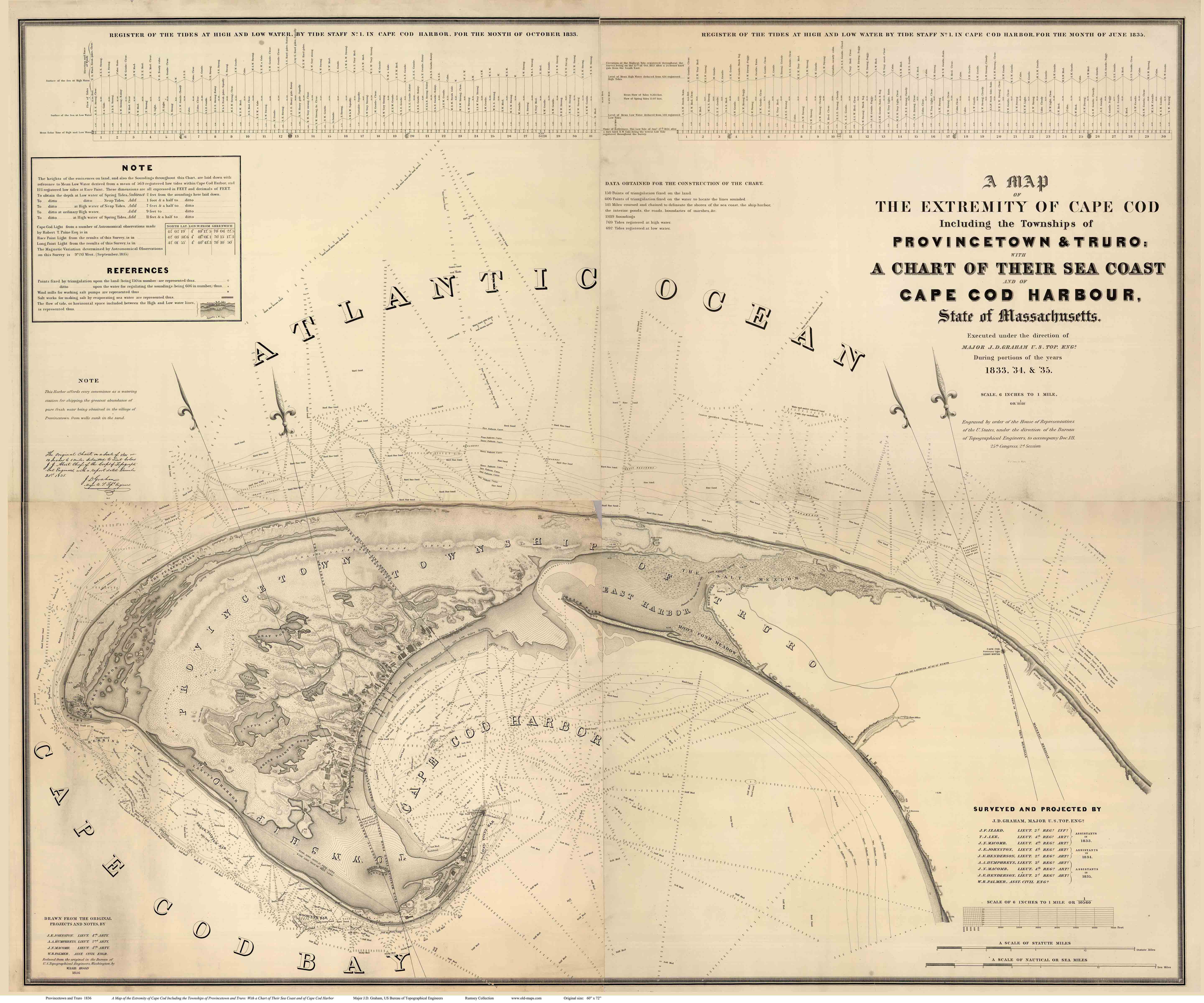
1836 Maps of the Provincetown area, Massachusetts
Two excerpts from "A Map of the Extremity of Cape Cod"
by the US Bureau of Topographical Engineers
Rumsey Collection
Click the map to see a more detailed copy.
(The image is degraded for the web, but it shows the areas covered by the map.) |
|
|

A Map of the Extremity of Cape Cod....
This is the original map from which our "Provincetown 1836 " map
was made. |
This remarkably detailed map was made over three years by the US
Bureau of Topographic Engineers, predecessor to today's Army Corp
of Engineers.
It is a very accurate map showing
buildings, the shoreline and water depths for Provincetown and
surroundings. Our print is excerpted from the much larger
original map (image to the left).
Below we show sections of the map, including the Legend (which is
not included on our 1836 Provincetown edition).
Purchasing information is
available at
shop.old-maps.com. |
 |
Above, "downtown" Provincetown in 1836. Each wharf is named , as
are principal buildings. The names "Parker" and Lothrop" may
denote prominent citizens, as most of the private buildings are
not identified.
The long rectangles are salt-drying
facilities.
The numbered circles on the hillside are
surveying control points. Accurate mapping at the time was based
on triangulation points, physical monuments on high, open
locations, whose position could be determined by measuring
intersecting angles from other known points. |
 |
|
The area around the Race Point Light House was very active, with
a cluster of Fisherman's and Pilots's Huts. The "Tide
Staff" was probably a wooden stake with elevation markings so a
sailor could see at a glance how shallow the water was. |
 |
|
|
|
|
|
|
|