Vermont:
State Maps
Counties:
Addison
Bennington
Caledonia
Chittenden
Franklin & Grand Isle
Orleans
Lamoille
Essex
Orange
Rutland
Washington
Windham
Windsor
Town/County Index
Bookstores
Press Releases
Articles/Research |
|
|
VT
State Maps
Covens & Mortier
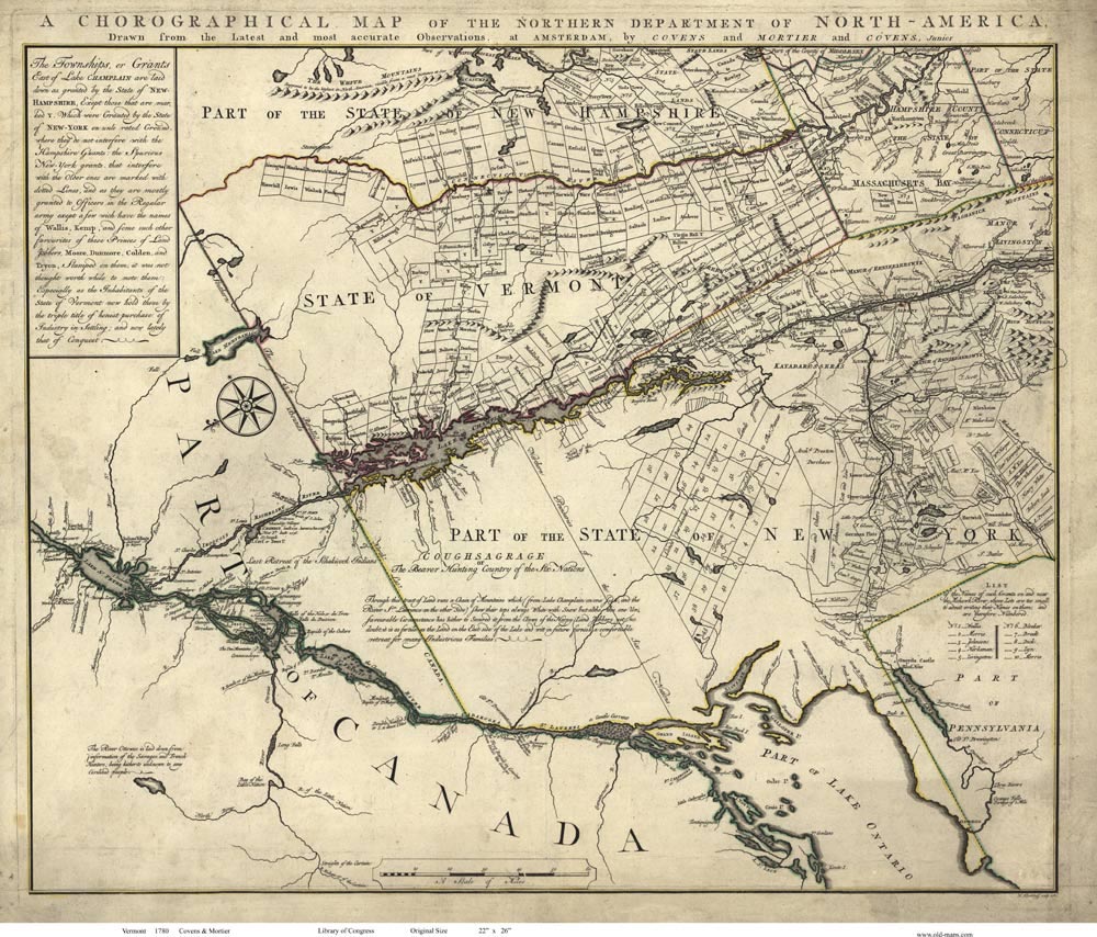
Map of Vermont
1780
The first
use of "Vermont" on a map.* Shows towns, includes part of New York |
| Home
State Maps |
Click here to purchase this VT State Map |
 |
 |
|
|
Click on the map above to see a more detailed copy.
Original size: 23" x 27" |
The images above show
the level of detail on this map |
 |
 |
 |
| |
*This is a copy of the true
"first map to use Vermont," which is the 1778 Map of Vermont by
Bernard Romans.
We do not have the 1778 Romans Map
available for sale at this time. |
|
"Chorographical Map of the
Northern Department of North America" Published in 1780 by Covens &
Mortier/After Bernard Romans
There is not a state that exists
today that had more obvious physical boundaries than Vermont and
whose eventual shape as a state was pre-determined by them. With the
Connecticut River to the east and to the west, 110 mile long Lake
Champlain running nearly half the length of the state, no state was
so clearly defined early on. Indeed, when Bernard Romans published
his "Chorographical Map of the Northern Department of North America"
in 1778, in which Vermont is named as a state for the first time, he
laid the state out in an almost perfect rendition of Vermont as the
state exists today, using the two bodies of water as the east and
west boundaries.
There is no mistaking Romans' allegiance to the
citizens of the newly established Republic of Vermont, who were
involved in a bitter struggle to free themselves from New York's
aggressive attempt to retain control over the region. He labels the
New York land grants as "spurious" and as being "issued to these
Princes of Land Jobbers, Moore, Dunmore, Colden and Tryon". The
settlers, on the other hand, are recognized as "The inhabitants of
the State of Vermont" that now hold their grants "by the triple
title of honest purchase, industry of labor and, lately, that of
conquest".
Romans' exceedingly rare map, of which only 2 copies
are known to exist, is renowned for his very odd orientation of the
region. Covens and Mortier, A Dutch cartography firm, re-published
Romans map in 1780 with no acknowledgement of Romans as the surveyor
and publisher of the original map. Such infringement, especially
with maps, was common before the U. S. Congress finally passed
copyright protection legislation in 1790.
Thomas Hasson/Owner
- Gulf Brook Fine Art & Antiques, 2014
|
Origins of the Name “Vermont”
Joseph-Andre Senecal, a retired professor at
the University of
Vermont holds the opinion that the name “Vermont” was coined by one
Thomas Young, in an article written in Philadelphia on April 11th,
1777. The term “Green Mountains” had been in use for about five
years at that time, and Senecal
believes that “Vermont” was
Young’s translation of that phrase into French.
(vert monts =
green mountains)
Many New England scholars have postulated
that “Vermont” was simply left over from the considerable French
presence in the Champlain Valley prior to 1760. This idea has been
widely accepted, but there is no tangible connection. Senecal
reports not finding “Vermont” in any French documents from that
time.
Senecal also suggests that Young was honoring Ethan
Allen and his Green Mountain boys with the translation, as the term
“Green Mountains” had been popularized
by that organization. |
“Romans” Map of Vermont 1778
The
map's author was Bernard Romans, a British naval officer, who was
sympathetic to the American cause - and also to Vermont’s desire for
independence from New York. On the map he describes the New York
land grants as “spurious” and as being “issued to these Princes of
Land Jobbers, Moore, Dunmore, Colden, and Tyron”.
The Vermont
settlers, on the other hand, are
recognized as “The inhabitants
of the State of
Vermont” that now hold their grants “by the
triple title of honest purchase, industry of
labor and, lately,
that of conquest”.
Mr. Romans' map was copied and re-issued in
1780 by Covens, Mortier & Covens. Their version is
not so rare. |
| |
|
|
|