Town Map Overlay Sets
For Ancient Roads Research |
|
On a special order basis, we make sets of 6 printed detailed maps at the same scale
for research into old roads and houses. Using these same-scale maps you can
easily analyse the locations of old roads and house sites by overlaying the
maps on one another. These sets have 3 new maps and 3 old maps.
These same-size map sets are a great time-saver for researchers.
(Many people have copies of these maps, but don't have the
ability to easily make them all the same size) |
 |
 |
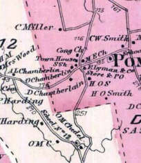
1856 - Oldest
from the "Map of Windsor County, 1856"- the oldest map
to show all houses and roads Pomfret. All
Vermont towns were mapped like this in the late 1850s. |
1986 - Modern
The 1986 map also shows all houses and roads. There is also a 2003 map which is more accurate and shows all road segments by number
and length. (It does does not show houses) |
|
Note the several differences between the 1856
and 1986 maps. Both maps show all roads and principal buildings. There
was a northwesterly road leading out of the center which has been stubbed off by 1986, and the main east-west
road from the center has been replaced by a more southerly looped road.
3 other maps of the same area are seen below. |
|
 |
 |
 |
1869 "Beers" Atlas
from the "Atlas of Windsor County", 1869, by F.W. Beers. The "Beers" maps provide different names and roads
than the 1850s map. There were many changes in New England as a result of railroads and the Civil War. |
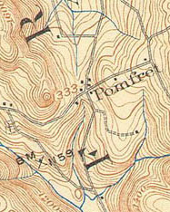
1908-11 Old USGS
The first USGS topographical
maps, are more accurate than the
earlier commercial maps. (These are also available for
free download at the UNH website - though you will need to piece the maps
together) |
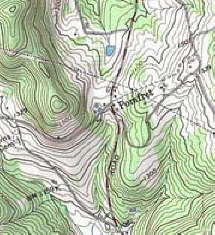
1986 Modern USGS
from the US Geological Survey. Accurate topography
helps to show landforms which might - or might not - be suitable for roads,
then or now. |
|
The same area is shown on these 3 maps. The 1869 shows
the north-south road already stubbed off, but the loop road going easterly
does not yet exist. The 1908 USGS map shows a driveway loop to the
south which later - 1986 at least, and on the 1996 USGS map - has become the
main east-west road. The 1996 USGS map shows the old east-west road as
a dashed line. |
Specifications:
Whole-town only - not including villages*
Paper prints at 1"=2000'.
Size varies with the town - most about 20" x 24".
2 prints of
2003 State Map on transparent paper for markups.
Shipped rolled in a tube. Allow 3 weeks for delivery. |
The 6 Maps
1) 1850s wall map
- house names and old roads
2) ca. 1870 "Beers" - house names and old roads
3) early 1900s USGS (1893-1941) -old roads
4) 1990s USGS - very
accurate and complete
5) 1986 State Hwy Map - houses as of 1986
6) 2003 State Hwy Map - accurate base map (2 copies) |
Set of 6 Town Overlay Maps for Road Research
$190 _____
"
" and CDROM (JPEG files)
$220 _____
**** Set of 6 Town Overlay Maps CDROM ONLY
$140
_____
(shipping / handling)
$ 10
To order a set of these maps, print a copy of this page, write your town
here: ________________. Write a check for $200 for the paper set (or
$230 for paper +CD; or $150 for CD only). Make your check payable to
Old Maps and mail to PO Box 54, West Chesterfield, NH
03466. Please allow 3 weeks for delivery, as these maps are made to order.
(Call 413-772-2801 days if you have any questions).
* Many of the old maps include village detail maps in addition to the
town-wide maps. These detail maps are not printed to scale in the
scaled Town Overlay Maps offering, but we do provide un-scaled paper prints. |
|
How we make them: An accurate base map is made
using the 2003 Vermont AOT street map at 1" = 2000', and then the other maps are printed
out at the same scale and size. For the modern and old USGS maps this
requires that we scan and combine sheets (many towns are on more than one USGS
sheet). The older maps (wall maps and "Beers") are tricky because they
weren't made by accurate surveys. We use road intersections to
calculate the scaling factor rather than town lines or the stated scale on
the map. This assures that the overlays are as close as possible to
the modern map. When using the older maps, you should consider
their lack of precision when doing road analysis.
Special Note to Ancient Roads researchers: The best way to get
started on Ancient Roads research is to make a Research Base Map showing old
roads from the 3 old maps. We suggest that this Base Map be drawn by hand on
one of the 2 copies of the 2003 State Highway Map we provide. Once you
have made this composite map you can add to it other roads you find in the
woods (many are not shown on maps) and roads whose existence you find from
records research.
Click Here to see an example of Research Base Map.
*** New February, 2008 - We
offer to make Historic Roads
Compilation Maps ***** |
