Old-Maps

Vermont
Massachusetts
New Hampshire
Maine
Connecticut
New York
Rhode Island
New England
About Us
News Coverage
Contact Us
Order Form
FAQ

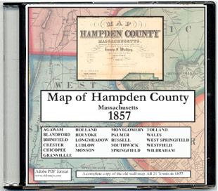
Masschusetts:
State Maps
Counties:
Barnstable, Dukes & Nantucket
Berkshire
Bristol
Essex
Franklin

Hampden
Hampshire
Middlesex
Norfolk
Suffolk
Plymouth
Worcester


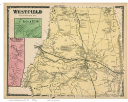
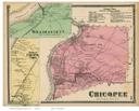
Town & County Maps
Hampden County
Massachusetts

Follow the links below to find historic maps of your area at different times.

You can explore our old site here, or visit shop.old-maps.com and search "Hampden" to see many more maps!
 
Hampden County Map Reprints from the 1857 Wall Map and the 1894 Atlas
1857 1894
   
1857 - Full Wall Map, CDROM, Town Prints  1894 - Town Prints 
 
1870 Beers Atlas 
 
Town Prints from the 1870 Atlas
 
 Birds Eye Views


Towns in Hampden County:
Agawam
Blandford
Brimfield
Chester
Chicopee
East Longmeadow
Granville
Hampden
Holland
Holyoke
Longmeadow
Ludlow
Monson
Montgomery
Palmer
Russell
Southwick
Springfield
Tolland
Wales
West Springfield
Westfield
Wilbraham
County/Town Maps

1) 1844 Borden State Map - Hampden Co. Excerpt
 

2) 1861 Walling State Map - Hampden Co. Excerpt
Early State Maps

Set of 30 New England maps on a CDROM
1755 "Douglass" Map of New England

Old State Maps of Massachusetts


Revised: 04/23/18
Copyright © 2005 [Old Maps]. All rights reserved.